Brighton Summits
A medium-loop course that will take you on a beautiful overlook of the Brighton Area
All racers will receive a race hat
*HAT IS UNDER DESIGN*
Make sure to read the full course description below for important information.
View Full Course Description
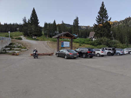
Parking: Park at Brighton Resort at the Brighton Lakes / Lake Mary Trailhead. This is near the Alpine Rose and the main Brighton Ski Lodge. This is the link to the parking lot address on Google Maps (click here)
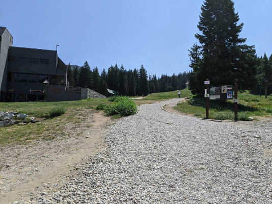
Start/Finish: The start and finish of the course are at the Brighton Lakes / Lake Mary Trailhead sign, a short walk up from the parking lot.
-
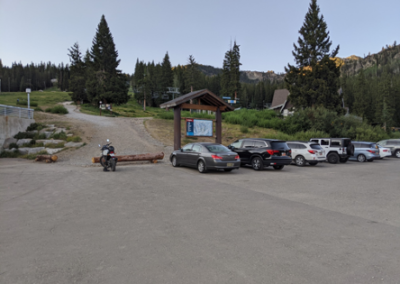
Parking for the Course
-
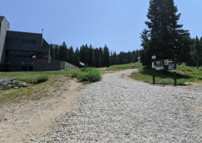
The start and finish of the course are at the Brighton Lakes / Lake Mary Trailhead sign, a short walk up from the parking lot
Notes From the Trail:
Clocking in at just under 8 miles and about 2,750’ of climbing, this course is challenging but manageable. It takes you on some very well-traveled trail up to Lake Mary, Catherine’s Pass, and on to Sunset Peak, but then traverses the ridgeline between Catherine’s Pass and Twin Lakes Pass, covering some steep and technical terrain with beautiful views the entire way! Don’t think it’s all downhill from Twin Lakes Pass, as you have a surprise climbing traverse from Twin Lake back to the Brighton Lakes Trail before your final descent. I recommend bringing plenty of water, or a filter bottle to fill up near Twin Lake. There is no water on the ridgeline.
You begin by climbing up the well-traveled Brighton Lakes Trail until you reach Lake Mary at about 1 mile. This is a relatively mellow and wide trail, with some rocky footing near the top.
From Lake Mary you stay left on the main Brighton Lakes Trail to skirt the side of Lake Mary and continue past Lake Martha and Lake Catherine. The trail braids some at each Lake, so make sure you stay on the obvious main trail.
At mile 1.9 the trail forks, and you will stay to the right to continue onto the Catherine Pass Trail. This is where the real climbing begins, and you’ll climb straight up to Catherine’s Pass.
Immediately when you reach Catherine’s Pass you will see a trail sign, this is a very important junction. You want to take a HARD LEFT down a faint trail that will take you on a traverse towards Sunset Peak.
The traverse trail is only 0.3 miles, but gets very steep and sandy in places. Stay left on this trail until you reach the main Sunset Peak Trail.
Turn left on the Sunset Peak Trail and continue up it for about 0.2 miles until you reach the summit. Nice work! Peak 1 of 4 done…
From the summit of Sunset Peak you will turn around and retrace your steps. When you reach the intersection with the traverse trail you came up, you will STAY LEFT to continue onto the main Sunset Peak Trail. Very quickly you will come to another intersection, where you will stay right on the wider Sunset Peak trail.This trail will wrap around a small knoll, and then descend back to Catherine’s Pass. Upon reaching Catherine’s Pass (for the second time), you will continue STRAIGHT onto a faint trail that climbs steeply up Tuscarora. If you’re in doubt at this intersection, take the only trail (other than the one you just came down) that goes UP instead of down.
The climb up Tuscarora is a steep and challenging hike, and the trail is faint. Just before reaching the ridgeline the trail splits, and you stay left to traverse around the first part of the ridge before climbing straight up the side of it. Follow the main trail in this section, and be prepared to us your hands on some sections!
Follow the trail off of the summit of Mount Tuscarora and drop down a slight dip before climbing up Mount Wolverine. This section is beautiful and full of wildflowers and views, but the footing is tricky!
From the summit of Mount Wolverine, you will descend on the obvious trail and begin navigating the ridge around Wolverine Cirque. WARNING: THERE ARE A FEW EXPOSED SECTIONS HERE. There is nothing too sketchy, but go slowly here and make sure you are confident in your footing. The initial descent of Mount Wolverine is steep and loose
Follow the GPS track closely around Wolverine Cirque, remaining on the main trail that keeps you away from the edge of the cirque. There are a few schwacky parts here, where you will be passing through some time alpine firs.
After completing the Wolverine Cirque traverse you will quickly reach the summit of Patsy Marley. On the descent from Patsy Marley, stay right and follow the main trail as best as you can in the rocky terrain. Check the GPS course track here if in doubt. The trail turns quickly back to dirt, and deposits you at Twin Lakes Pass.
From Twin Lakes pass it is IMPORTANT that you continue straight for a short stretch before taking the right hand turn onto the Twin Lakes Pass Trail. There is a sneaky trail just before your right hand turn that looks correct, but is not!
Once on the Twin Lakes Pass Trail, you have a beautiful descending traverse until you enter the Solitude Ski Area boundary, where you will drop down onto the Summit Access Road. Take a right on this dirt road and then continue straight. It quickly reverts to trail and takes you down and over the Twin Lakes Dam.
Immediately after crossing the edge of the Dam, you will take a right onto a dirt road. This will take you to a dirt road intersection, where you stay RIGHT to head up a short but steep climb. At the top of the steep climb, look to the left for the single track Granite Lakes Trail, which you’ll take.
Follow the Granite Lakes Trail for about 1.1 miles, until it intersects with the Brighton Lakes Trail you initially climbed up. Turn left and head all the way back down to finish at the Trailhead sign you started at.
Safety/Warnings and Advice: You are on your own. The course is not marked. There is no support on the course whatsoever. Bring plenty of food and water. Bring a topographical map and know how to use it. Practice proper trail etiquette. Make sure your fitness app/phone has the course downloaded and is fully charged so you don’t lose your way. Apps such as Strava can wear down your phone’s battery quickly. Make sure your battery will last several hours. Weather at this altitude can change quickly. Brief yourself on the weather. Do not go if there is chance of thunder and lightning. Early morning start is recommended as it avoids the heat and gives you plenty of daylight.